Resource Acknowledgments
The following resource was created in collaboration with Paul Drake, architect, and Lenore Braford, founder of Piedmont Farm Animal Refuge.
What Is A Site Plan?
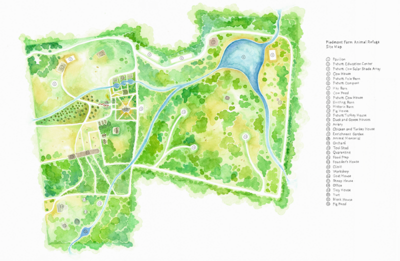
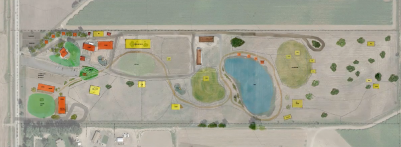
A site plan is a drawing of an area of land that includes all existing features (natural and man-made) as well as proposed projects such as new buildings, animal areas, or infrastructure. It is a design tool that can help sanctuaries make informed decisions about new projects, whether they involve the addition of one new structure or a long-term expansion plan (also known as a master plan).
Why Is Site Planning Important?
The process of site planning helps sanctuary leaders envision the future form of their land and enables them to have a more holistic approach to sanctuary design. A site plan can help identify possible building sites and evaluate the pros and cons of each. In addition to being a useful tool during the planning of individual buildings, it’s a great way to plan for future growth and can help sanctuaries avoid the headaches that typically come with a more piecemeal approach. For example, a sanctuary may start out caring for one species but have plans to eventually care for additional species, or a sanctuary may start out with just resident housing, but have plans to eventually add an education center. Instead of figuring out each new structure when a sanctuary is ready to begin the project, it’s helpful to consider all future projects together so that each is placed thoughtfully on the land. This will result in a more cohesive setup.
Speaking of future projects, a site plan can be a great way to communicate your long term vision to donors, which can be useful in securing funding. Instead of just explaining your vision to them, a site plan allows donors to actually see your plans for the future!
Getting Started With A Base Map
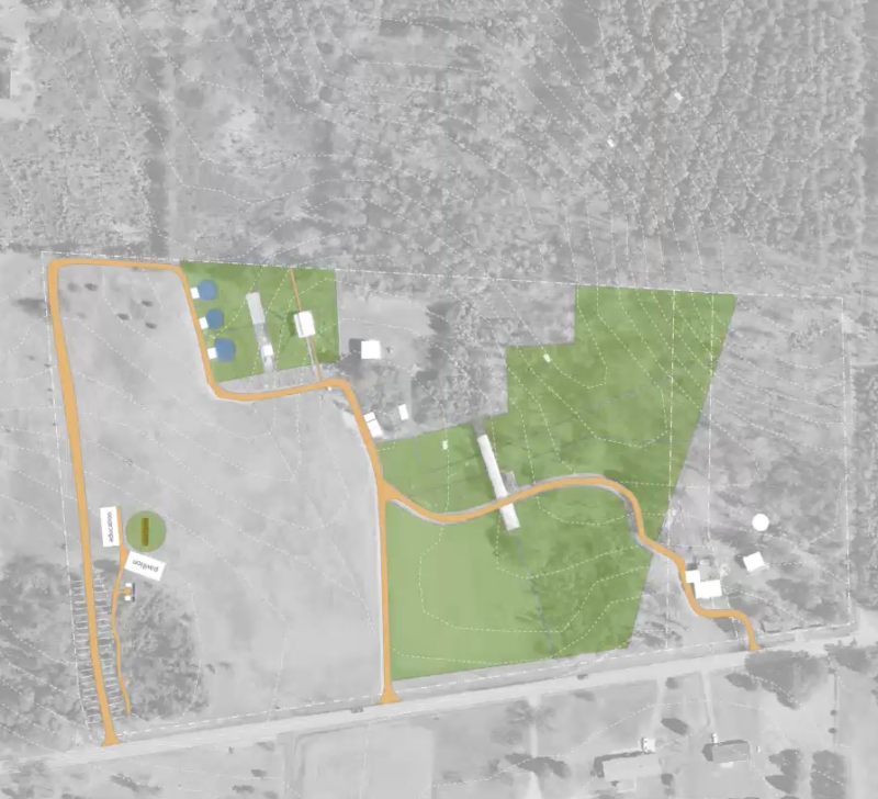
Site planning may sound daunting, but it’s actually quite accessible! While you can certainly contact local architecture firms to see if they’d be willing to do some pro bono work, site planning is possible without getting professionals involved. To get started, you’ll need a large base map of your property. This is a detailed drawing of the existing site that will form the basis of your site plan drawing. You can use a survey map, google map, or your county’s free Geographic Information System (GIS) mapping service. It can be very useful to have the base map printed in large format by a local printer so that you have a physical copy. Make sure that it is printed at a large enough scale that you can make out the various features of the site – 24 inches tall by 36 inches wide is typically a good size (aka Arch D size).
Later on in the site planning process, you and other stakeholders can use this large drawing to begin brainstorming together on the future form of the sanctuary. When we use the term ‘stakeholders,’ we are talking about anyone who has an interest in or around your sanctuary, your residents, and your operations. Stakeholders include caregivers, your administrators, and potentially your board, as well as neighbors and other parties who may have a special interest in your sanctuary, such as community groups, potential collaborators, or other organizations interested in supporting shared goals with regards to collective liberationCollective liberation recognizes that all systems of oppression are intertwined and acknowledges that working in solidarity with one another to undo all of these oppressive systems is the only way we can achieve a world where everyone, human and nonhuman, is truly free from exploitation and harm..
Additional Protection Associated With Land Surveys
Property surveys can give you a precise understanding of your property’s boundaries, but they can also do so much more! Surveys are a visual indicator of restrictions on land such as rights-of-way, setbacks, buffer zones, and easements, environmental concerns, or things like encroachments on land by structures on neighboring properties like fences or buildings. All of these are essential things to be aware of when you purchase a property or plan construction so that you know exactly what you’re buying and what you can and cannot do on the property! To learn more about surveys and how they can help your animal sanctuary, check out our resource here!
Good base map drawings include many different types of information about the existing site. Each unique type of information content on a map can be thought of as a “layer.” Online County GIS maps allow users to turn layers of information on or off, depending on what the map will be used for. Below is a list of some important layers you should consider including in your base map:
- Recent satellite photo
- Property lines
- Topography (aka contour lines)
- Streams or other bodies of water and associated buffer zones
- North arrow
- Graphic scale indicating distance increments
- Notable neighboring properties and their uses
- Existing infrastructure: including buildings, roads, fences, utilities, wells, septic, etc. (Some of this information may need to be added to the map if not included on the GIS website)
- Setbacks from property lines, well, septic, etc.
If you’d like to learn more about using your county’s GIS mapping service, check out the video below!
Video Resource: Creating A Base Map Using Your County’s GIS Mapping System With Paul Drake
Site Planning Considerations
Before you start exploring and evaluating different site possibilities, it’s important to identify all the factors that should be considered when assessing various locations. You should prioritize the residents’ needs, but you’ll also need to factor in practical considerations. These include:
1. Local Zoning Codes
If you are just getting started with your sanctuary, or if you’re not sure whether farmed animalsA species or specific breed of animal that is raised by humans for the use of their bodies or what comes from their bodies. are permitted on your land, you will want to check the zoning designation of your site (for example: residential, agricultural, business, etc.). Your county should have a zoning map accessible online, which shows what zone your site falls under, as well as a zoning ordinance, which lists the permitted uses of your zone. It is important that you make sure what you want to build is permitted within your zone (and also that the individuals you plan to care for or the activities/services you hope to provide are permitted). Your county may also want to set up a site plan review process, the exact details of which will vary from county to county.
2. Buffer Zones And Setbacks
Per local county regulations, certain areas of your land may have zones where you are unable to build due to buffers or setbacks. Buffer zones typically exist to protect natural features such as wetlands or streams. Setbacks are non-buildable areas near features such as property lines, wells, or septic sites. Check with your county’s environmental health department for more information on buffer zones and setbacks before you begin the building process.
3. Animal Residents
After considering zoning, buffers, and setbacks to identify areas of the sanctuary that are off limits, it’s helpful to spend time focusing solely on what your residents need to thrive, particularly when considering the location of animal resident structures (versus those intended for humans such as caregiverSomeone who provides daily care, specifically for animal residents at an animal sanctuary, shelter, or rescue. housing or an education center). If your resident were able to create their own wish list, what would be on it? What type of terrain do they prefer? What type of vegetation? Would they want access to a pond? With your residents’ desires in mind, there may be certain sites that jump out as being good possibilities.
4. Staff, Volunteer, And Care Provider Accessibility
Be sure to consider how easily staff and volunteers can access the site. For example, if accessing the area involves a long or arduous walk, you may find that staff must use a vehicle to get to the site in order to keep the daily workload manageable (or that you need to have a vehicle available in case quickly getting to the building is necessary). If you have a mobile veterinarian, farrierSomeone who provides hoof trimming and care, especially for horses or cows, or other care provider who will need to access the area, be sure to consider how easily they can do this with any supplies they may need.
5. Terrain
You’ll also want to consider the terrain. For starters, is the area where you hope to build level? If not, this will add to building costs. Additionally, the grading required to create a level building pad may result in slopes in other areas that you did not anticipate (for example, you may find that creating a level building pad for a new cowWhile "cow" can be defined to refer exclusively to female cattle, at The Open Sanctuary Project we refer to domesticated cattle of all ages and sexes as "cows." structure results in the residents’ having to walk up a hill to get into the structure). What kind of soil is in the area? Certain types of soil or the rockiness of your land will make building more labor intensive and more expensive. Also consider how the terrain will impact fencing. As with building construction, some terrain will make fencing more labor intensive and more costly.
6. Seasonal Considerations
Think about seasonal weather patterns and precipitation, and consider how these will impact the site itself as well as access to the site (as described above). Take into consideration the types of severe weather that are possible in your region and whether or not certain areas of your property are more or less at risk. For example, if mudslides are possible, you’ll want to avoid building in areas most vulnerable to mudslides. In areas where wildfires are a concern, you’ll want to build with this in mind, considering ways to make the structure more easy to defend. Also consider how sun direction and the prevailing wind will impact keeping the structure comfortable during hot or cold weather.
7. Run-off/Drainage
Consider the slope of the site and surrounding land. Does this area get overly wet/muddy following rainfall/snow melt? Keep in mind that residents grazing, rooting, or constantly walking over certain areas may kill vegetation, which will make land more prone to becoming muddy. Also consider where run-off from the site will go and how this might impact bodies of water, wells, and other resident areas. For example, runoff from cow resident spaces could contaminate duckUnless explicitly mentioned, we are referring to domesticated duck breeds, not wild ducks, who may have unique needs not covered by this resource. ponds making algae and cyanobacteria growth likely. Similarly, pay attention to where run-off coming to the site is flowing from as this is also a potential source of disease spread. For example, if there is a pond nearby that wild waterfowl visit, run-off from this pond into avian resident areas could spread avian influenza.
Also be sure to consider how new infrastructure will affect drainage patterns. Many times new infrastructure will redirect flows of water. In soils that are prone to becoming muddy, it is important to consider how water flows can be channeled to areas that don’t have a lot of foot traffic. In order to keep the interior of animal structures dry, it is also important to make sure that the ground around the structures slopes away from the structures (“keeping animal structures high and dry”).
8. Utilities
When considering different sites, it’s important to consider any existing utilities as well as utilities that will be run to any new structures. Are utilities overground (such as overhead power lines), or will they be underground? Does other underground infrastructure exist that may be encountered? In the US, folks can call 811, a free national service that identifies and marks existing underground public utilities. However, this service will not be able to identify any existing private utilities.
If you plan to run electricity or water to the building, you’ll need to consider the feasibility of this. If you do not plan to run water or electricity to the structure, be sure to consider how you will keep the space comfortable during hot or cold weather and also consider the labor involved in ensuring residents will always have access to fresh, clean water. When installing new utilities, keep a detailed record or map showing the locations and routes of all utilities. This will help you avoid digging through them in future construction. When running underground utilities, try to plan for the future so that you don’t have to dig the same trench twice. You can save both time and money by thinking ahead and by building in capacity for future expansion.
If you do not have access to public sewer utilities and are looking to install bathrooms, you will likely need to have a septic system installed, including a tank and leach field. The leach field, in particular, can be very large depending on the types of soils you have and how many people are expected to use the bathrooms on a regular basis. Check with your local environmental health department for more information.
9. Proximity To Neighbors, Roads, Other Resident Areas, etc.
Consider how close the site is to neighboring land and how that land is used. For example, if there are other domesticatedAdapted over time (as by selective breeding) from a wild or natural state to life in close association with and to the benefit of humans animals living on neighboring land, you may need to avoid situations where your residents and neighboring animals can come into contact with each other. Also consider proximity to human neighbors and whether or not certain residents should be housed away from them in order to reduce the risk of complaints related to “noise,” odors, or flies. If hunting is allowed on neighboring land, you’ll want to avoid having residents near the property line during hunting season both for their safety and the safety of your staff.
Also consider proximity to public roads. There are various risks associated with residents leaving the safety of their home, but these risks certainly increase if there is a public road nearby, particularly if it is a main road. In addition to this, in dry areas, proximity to roads may increase the chances of a brush fire, so it may be wise to keep structures and resident living spaces away from roadways whenever possible.
You’ll also want to consider the proximity to other resident areas. Are there certain species that should not have close contact with one another? Alternatively, perhaps there are certain species that you want to house near each other, particularly if you have plans to rotate different species through the same outdoor spaces in order to mitigate parasite issues. In addition to proximity to other resident areas, also consider the other animals who call your sanctuary home. Building on certain parts of the property might make conflicts with wildlife more likely.
10. Vehicle And Equipment Accessibility
How easily can building equipment access the proposed site? Depending on the location and surrounding terrain, as well as the equipment that will need to access the site, you may need to clear areas of land you did not intend to disturb. Once completed, what types of vehicles and equipment will need to access the building? Be sure to consider how feasible this is (which may be affected by seasonal considerations, as described above). For example, perhaps you feel that the best location for your pig residents is a wooded area that is located on top of a large hill. You’d want to consider how easily you’ll be able to access the area with a transport vehicle. Perhaps this is completely doable during fair weather, but what about during heavy snow (if that is possible in your area)? If accessing the area will require snow removal, is this feasible?
Don’t forget to consider equipment and vehicles that are necessary during emergency situations. For example, in the event of a fire, how easily would emergency responders be able to access the site? Given the dire consequences of a delayed response, it’s a good idea to contact your local fire department to determine what they need for a quick response (which may include access roads of a certain width, having enough room to turn around at the site, having a way to enter through gates that are usually kept locked, and being aware of bodies of water on the property that could be used as a water point). Similarly, also consider how easily residents could be evacuated from the site, if needed.
11. Tour And Visitor Accessibility
While the residents’ needs and desires should absolutely come first, if your sanctuary offers tours or other opportunities for folks to visit, you’ll want to consider whether or not you want the proposed structure to be accessible to visitors. If, for example, you want to include a stop by the completed structure as part of your tours, be sure to consider how possible sites fit into this plan. While not always feasible, creating a tour “loop” that leads visitors back to where they started can make things easier on guests.
Identify Potential Sites
With the above in mind, start identifying spots that seem like good possibilities for the project(s) you are considering. Remember that base map we told you to make? It can be helpful to use trace paper to sketch proposed structures or to use sticky notes cut to different sizes to represent structures on your map (as shown in the mock site planning session video below). This can help you and your team visualize different possibilities and can make it easier to “try out” different sites. You can even use a piece of string to experiment with routes staff and volunteers might follow when accessing the site to get a better idea of how the site will impact daily operations. Similarly, it might be helpful to use a string to map out different tour paths if the new site is to be incorporated into public tours.
While the base map you created can help your team identify potential sites, it’s also important to walk the land and visit possible sites. Just as there are certain things that may be apparent on a base map that may not be obvious when visiting the site, there are also things that you will notice when visiting a site that will not be apparent just by looking at your base map. If you can, it’s helpful to let some time pass so that you can observe the site in different conditions. Visiting the site after heavy rainfall or after the snow has melted can give you a better idea of drainage and mud issues. Consider inviting members of your team out to the different sites so they are better equipped to provide feedback.
Hold A Site Planning Session
Once you’ve got one or more possible sites identified, you can start soliciting feedback. One of the best ways to do this is by having a site planning session where a team of folks with different perspectives can discuss the pros and cons of each site. It’s a good idea to ensure that key perspectives/knowledge areas are represented in your site planning meeting. This includes folks with knowledge of the site(s), building experience, familiarity with day-to-day animal care at the sanctuary (such as feeding, habitat cleaning, and healthcare), and experience with your sanctuary’s education programing, if applicable. You also want to have at least one person involved who has a deep understanding of the species in question and their needs. If you have a good relationship with your veterinarian, they may also be a good source of feedback, as they might identify concerns or considerations you didn’t think of. Holding a site planning meeting with folks who have different areas of experience allows you to thoroughly assess the pros and cons of each potential site.
It can be helpful to start by talking as a group about the general requirements for the project. If your meeting consists of folks with different areas of experience and knowledge, together you should be able to create a comprehensive list. Then, you can start evaluating each possible site. We suggest hanging your map on a wall or otherwise displaying it and using magnets, stickers, sticky notes, string, pins, or something similar to represent proposed infrastructure. This will allow folks to better visualize things. During this part of the process, spend some time talking about each site, one at a time, considering the opportunities and challenges that come with each. We recommend using the checklist below to help with this process! Again, while the needs and the desires of the residents should carry the most weight, you do also want to balance that with the needs of your staff and volunteers, as well as with your general operations.
After discussing each potential site, talk as a group about how these possibilities stack up against each other. Does one jump out as best meeting the needs of your residents and personnel? No location is going to be perfect, so you’ll want to consider the pros and cons of various locations being sure to keep your residents’ needs at the forefront. If you’re interested in learning more about what a site planning session might look like, check out the video below!
Video Resource: Mock Site Planning Session With The Folks At Piedmont Farm Animal Refuge
Video Chapters And Highlights:
0:15 – Introduction
1:49 – Overview Of The Three Sites
4:36 – Pros And Cons Of Site 1 – “Pavilion Pasture”
19:34 – Pros And Cons Of Site 2 – “Pig Pond”
32:53 – Using A String To Map Out Possible Tour Route
34:05 – Pros And Cons Of Site 3 – “Forest Retreat”
38:22 – Using Trace Paper To Brainstorm Road Placement
44:43 – Choosing A Preferred Site
Download The Open Sanctuary Project’s Site Planning Checklist
Enter either your organization’s name or your name and email below to download a free printable double-sided checklist to help you evaluate proposed sites! We promise not to use your email for any marketing purposes!
Would you prefer to access this checklist in a different way? Contact us and let us know!
How’s This Checklist Working For You?
Have you used this checklist at your sanctuary and want to give us your feedback on improvements? Let us know here!
References To Outside Organizations?
This resource contains links or photos provided by an outside animal-focused organization. You can learn about our organization’s position on endorsements here!


